
Iowa Civil War Monuments
Marion County
Gosport - Elm Tree Memorial Park GPS Coordinates: 41.206566 by -93.151700
This monument marks the spot under an elm tree where a number of Iowa boys assembled and marched to Davenport – then joined a variety of regiments. The original monument has a plaque on a boulder and was dedicated by the DAR in 1936. The second plaque has the names of the soldiers and was dedicated on July 1, 1995 by Veterans and descendents of these soldiers. The soldiers joined the Iowa 3rd, 8th, 15th, 31st, 33rd, 40th, and 47th Infantry Regiments. To find this tiny park on the site of the old town of Gosport (which no longer exists), take Highway 14 south of Knoxville for about 7 1/2 miles, then turn west on the Melcher-Dallas road (G76), then turn north on 103rd Avenue for about 1/8 of a mile to find the park. Photos taken 10/20/07. For much more information , see Historian Frank Myers' blog "The Lucas Countyan" - look under "Civil War Related."


Knoxville - Soldier, Peace Tree Plaque, Civil War Artifacts GPS Coordinates: 41.318800 by -93.097383
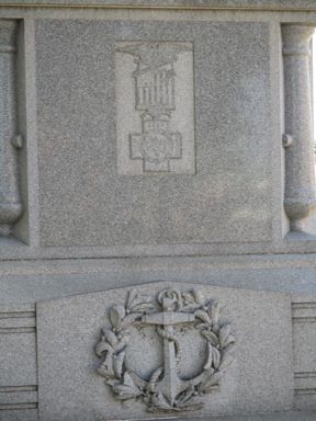
This monument has a statue of a Civil War soldier but is "Erected to the memory of the soldiers, sailors and marines of all wars." It was dedicated November 11, 1920. It is an attractive granite monument about 25 feet high on the NW corner of the courthouse square in Knoxville. Just southeast of the Monument is the Peace Tree plaque. This is dedicated to the spot under a tree where 40 soldiers enlisted on February 4, 1863. The original tree, of course, is gone but a replacement tree is located here and shows up behind the Monument in the photo. In the courthouse is a case of CW artifacts including swords, a sash, canteen, bugle, powder horn and GAR ballot box. It includes a large collection of GAR ribbons from Captain Charles Wells of the 8th Iowa. Photos taken 8/6/10 of the monument and plaque and 11/18/08 of the case in the courthouse. The 4 photos of the sides of the monument were taken 8/9/18.


Knoxville - Governor William M. Stone Memorial and Freedom Rock GPS Coordinates: 41.320383 by -93.121383
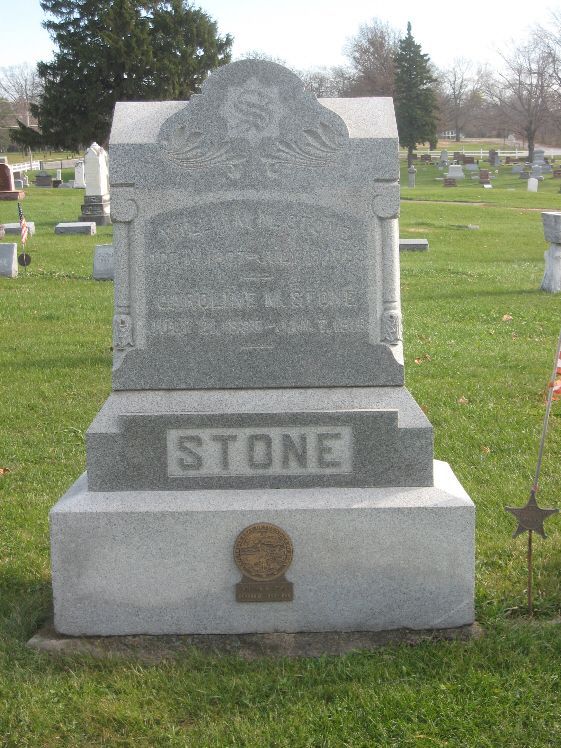
William M. Stone (1827-1893) was the Colonel and commanding officer of the Iowa 22nd Infantry Regiment. His regiment led the Federal charge at Vicksburg on May 22, 1863 and were the only Federal troops to actually occupy Confederate positions for a period until being driven back. Col. Stone was wounded in this battle. After resigning from the Army, he ran and was elected as Governor of Iowa for the 1864-68 term. He was at Ford's Theater the night President Lincoln was shot and helped carry the wounded body across the street. He had a law practice in Knoxville after serving as Governor. This unpretentious memorial, considering he was a former Governor, is in Graceland Cemetery in Knoxville. The inscription is difficult to read. Other family members are buried near-by. As you enter the cemetery, bear right and after rounding a curve in the road, the gravestone is on the left. Take Pleasant Street west to the west edge of town - it is near the Veterans Hospital. The first two photos were taken 11/18/08.
Artist Ray "Bubba" Sorensen painted a Freedom Rock that honors William Stone and Dixie Gebhardt, a Marion County native and designer of the Iowa Flag. It is located on 526 N. Lincoln Street in Knoxville just south of the Race Track. These photos taken 8/21/20.


Pella - Civil War Monument and Cannon GPS Coordinates: 41.407200 by -92.916883
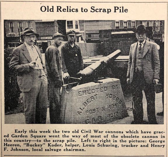
This is a very attractive 18 foot monument in the SE corner of Pella’s town square, erected in 1911. The statue is said to represent Captain Albert Hobbs of Pella who was killed at Shiloh on April 6, 1862. The GAR post was named Albert Hobbs Post #404. A 155mm Japanese howitzer Type 4 is near-by. I formerly lived in Pella and remember well playing on this cannon as I was growing up. Monument photo taken 9/29/07 and cannon photos taken 5/10/09. The close-up photos were taken 9/25/18. In 1912, two Civil War cannons were placed by the monument. These were scrapped for metal for World War II in 1942. The Japanese cannon was received in 1948 - see final two old photos. Thanks to the Pella Historical Trust for information.


Pella - Central College Civil War Memorial GPS Coordinates: 41.400716 by -92.919856
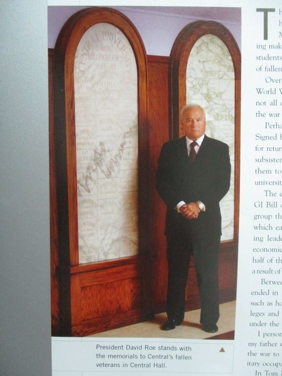
When the war broke out in 1861, many male students left college and joined the army. This marble memorial honors the students killed in the war. Four of these students were members of the 3rd Iowa Infantry Regiment and fell at Jackson, Mississippi on July 12, 1863. This memorial is currently in storage on the Central College campus in Pella - there are plans to display it in the future. The original memorial was installed shortly after the war but was destroyed in a fire in 1922. This replacement is identical to the original. The first photo was taken 12/20/10 - the second undated photo shows the names more clearly - the final photo is of College President David Roe in 2006 with the similar Civil War and WWII Memorials.


Pella - Plaque dedicated to James Murray Cox GPS Coordinates: 41.406450 by -92.914100
J. M. Cox (1845-1925) enlisted as a drummer in Co. G of the 17th Iowa Infantry in l862 at the age of 16. He was taken prisoner and paroled on December 20, 1862 at Holly Springs, Mississippi. He re-enlisted in the same regiment in 1864 and was promoted to Principal Musician and was the leader of the regiment's band. He again was captured at Tilton, Georgia on October 13, 1864 and sent to Andersonville Prison where he remained for over 7 months until the war was over. The band, captured intact, often played in prison. Known as Murray Cox or "Captain" Cox, he returned to Pella after the War and was a leader of town bands for many years. He was active in the GAR and a prominent town citizen. On September 28, 1922, a new bandstand in Central Park was dedicated in his honor. It is believed the plaque was also dedicated and placed on the bandstand at this time. In recent years, the bandstand was taken down and the plaque was moved to the Pella Historical Village at Franklin and E 1st Street on the east edge of the Pella business district. Photo taken 9/1/11.

Swan - Unknown Soldier Memorial GPS Coordinates: 41.464383 by -93.324683
This is an unknown soldier memorial for a soldier who died in 1863. There are medallions for the CW, WWI, WWII, Korea and Viet Nam. It is in the Swan Cemetery just west of the town of Swan - and just east of Highway 316. The memorial is small and difficult to find when the flags are not flying - go to the NE portion of the cemetery near the east fence. Photos taken 6/18/08 and 8/6/10.

